Good Sunday, everyone. To further cement the title of “the never-ending winter”… another winter weather maker is rolling into the commonwealth today. This will bring rain, snow, sleet and a touch of freezing rain our way and may cause some travel headaches for some.
Let’s break it down…
– Rain moves in from southwest to northeast. We’re likely to stay rain deep into the afternoon hours before a slow change to frozen takes place. That happens from north to south.
– The prime time for wintry weather comes this evening into early Monday morning. This looks to be a wintry mix of snow and sleet with some light freezing rain a good bet.
– The precipitation will wind down pretty quickly from west to easy early Monday morning.
– Accumulations will be held in check by a warm ground and the fact we’re likely to see different forms of precipitation and not just snow. Here’s the updated call…
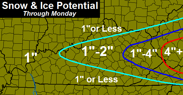
– As you can see, I expect the highest totals across the far eastern part of the state. Accumulations won’t likely take place until late this evening into tonight. Most of that will be on grass and elevated surfaces, though slick roads will be possible as temps tumble through the 20s.
I will update the call map by early afternoon. Until then, I have some tracking toys…

Hamburg Area from WKYT Studio
Lexington

I-75 @ Winchester Road Lexington

I-75 @ Iron Works Pike Lexington

I-75 @ Clays Ferry Bridge South Between Lexington and Richmond

US 60 @ US 127 Frankfort

US 127 @ Frankfort Frankfort

View of Downtown
Cynthiana

I-75 at MP 36 London

I-71/I-75 at Buttermilk Pike Near Covington

I-71/I-75 at Mt. Zion Rd.
Near Covington

I-64 @ 3rd St. Exit Louisville

Downtown Louisville @ 2nd & Broadway Louisville

I-65 @ 234 Near Bowling Green

I-24 MP 7 @ US 62
Paducah

Have a great day and take care.

Go away weak snow, its spring now, see you next December 😉
Four more days until the equinox.
Grrr. Warm ground. Always something eating into the snow totals around here. Winter didn’t really start until January this year, so it is interesting that 2½ months of winter gets everyone around here so tizzied.
Well we have seen plenty of snow in lexington lol.
WSW just went into effect and this map says 1-2″. Hmm
I am guessing you meant to say a Winter Weather Advisory, not a WSW. Big difference. Charleston is discussing, tho, issuing a WSW along the I-64 corridor in WV.
I don’t live in charleston, We’ve been under Winter Storm Warning since last night in central WV. FYI
What area has a WSW?
Temp was 44.1° at my house in NE Louisville @ 5am.
It is now 36.9°…I would say the cold air is moving in quicker than anticipated?
No changes in my forecast. Hopefully someone gets a good four inches or more out of this, I’d hate to see such an interesting and difficult storm leave us with nothing but boring old rain. haha
I guess us folks here in the south might as well hang it up for any snow. Thanks Chris Bailey, your the best!
Been working in yard since 8 o’clock this morning here in the The Ville!!! Go Cards!!! Spitting sleet and snow. I Like the radar returns and hope the cold air keeps funneling in. Was 41 now 35 degrees!
Serious verga (spelling). Dry as a bone and bone chilling here in Frankfort!!
Sleeting in east frankfort!