Good afternoon, folks. It’s back to winter we go as a mix of precipitation moves into the bluegrass state. Rain and sleet are being reported across many areas as of this writing. Snow will enter the picture as the day wears on as temps continue to fall.
I’ve made a few changes to the snow and sleet forecast. Here’s the last call…
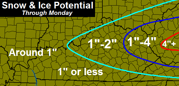
The highest totals will be across the east and northeast. There is some indication of a heavier band of snow trying to set up within that 1″-4″ zone I have. We will have to wait and see about that. No matter where you are, much of the accumulation will be on grassy and elevated surfaces.
Travel conditions may go downhill late this evening into early Monday as temps drop into the 20s.
That’s all I have for now. Let’s get back to our regularly scheduled tracking, already in progress…

Hamburg Area from WKYT Studio
Lexington

I-75 @ Winchester Road Lexington

I-75 @ Iron Works Pike Lexington

I-75 @ Clays Ferry Bridge South Between Lexington and Richmond

US 60 @ US 127 Frankfort

US 127 @ Frankfort Frankfort

View of Downtown
Cynthiana

I-75 at MP 36 London

I-71/I-75 at Buttermilk Pike Near Covington

I-71/I-75 at Mt. Zion Rd.
Near Covington

I-64 @ 3rd St. Exit Louisville

Downtown Louisville @ 2nd & Broadway Louisville

I-65 @ 234 Near Bowling Green

I-24 MP 7 @ US 62
Paducah

Take care.

Presently 34F and sleet here in east Lexington. Been sleeting for the last 30 minutes or so.
Very gusty winds out of the east this morning during the Cincy Heart Mini 5K but still no precip as of 1pm.
32 and sleet here in Lawrenceburg, KY. Slight accumulation on the deck already. Surprised by this during the middle of the day.
Heavy sleet here in Ashland ky
Yuck! So cold and wet and windy. Sleeting here in Lexington and seeing an occasional flake here and there. I haven’t seen anyone say the mix will start this early, most said 3-5pm or so. Currently 33° and keeps dropping. If this keeps up, soon enough sleet will accumulate and snow might (?) come earlier than expected?
It is nasty. Wind chill in the low 20’s–driving sleet. This feels awful after 60 yesterday!
When was the last few years we’ve had 1″+ after March 15?
I know we had an inch on April 6, 2007 (opening day of Keeneland). We also had 10 inches on March 20-21, 1996 and 3 inches on April 1, 1996.
High pressure the north keeping this low going due east. Not much northern movement with precip shield. Do like the looks out west to St. Louis. Could get ugly for some.
Thanks for the update CB!
Snowing now in Boyd Co.
All rain in Pikeville, waiting for the transition.
42 and rain here in Carrie
Snowing now in ashland
Windy and light rain here.Feels much colder.Above 70 yesterday and its setting on the freezing mark now.Sure hope we don’t get a lot of sleet like the last time.Took two days of warm temps to melt it.Maybe this will be our last round of winter but probably not.
Moderate Sleet and Snow 8 miles south of Louisa in Lawrence Co. Temp is 33. This has been going on for the last 30 minutes or more. It has gone from rain and sleet to sleet and snow over that time and it continues to “slush up” on my truck.
Snowing HEAVY in greenup
Sticking to all surfaces here too
Heavy snow here in Huntington, WV.
Never rained here In
charleston just heavy snow. Could this thing be an overachiever?…..
Heaviest I’ve seen it snow all year
Temperature has been dropping all day in Clay County. It is 36 degrees as of now and raining.
Holding around 40 here in Carrie of knott co very light rain
Looks like bulk of precip will stay north of seky
Lt rain to moderate sleet in Valley Station near Louisville
35 degrees
Enjoy the game….
I will be surprised if many of us beyond far eastern KY see an inch total from this. It will be gone quickly anyway, so no harm no foul. Hopefully we will get some wind to help dry roads off some to reduce slippery roads.
Already have over an inch here in greenup
My deck here in Menifee is now VERY slippery!
Winter storm warnings here in ne ky
64 corridor storm, same as the rest of winter
Already have an inch in Russell (Greenup County) and it is still coming fast and furious- big fat flakes.
Hoping this means it is moving through faster than anticipated.
Snow mixing in with sleet in Lawerenceburg. A small accumulation in spots.
Half sleet and snow in Lexington coming down fast! Starting to accumulate.
Yesterday was wonderful out and about, and today is just as wonderful. I love way the snow is falling. Heavy and with meaning. We should hit our inch in no time.
All snow now in Lawrenceburg. 32 degrees. Radar looks healthy for overnight–I would say we should see accumulations pick up after the sun goes down.
Around 2.5 inches here in greenup so
Far
saw decent flurry during the game…way to go CATS!!!
great fight and something to build on for the tournament.
shame on the haters!
started out as sleet around 12:30 then quickly changed over to snow! We have around 2 1/2 – 3 inches of snow so far!
37 and nothing falling from sky at moment in Carrie of knott co
Latest RAP model shows axis of heaviest snow across eastern KY along and north of I-64. Already reports exceeding 2″. Another couple of inches likely. Ashland, Greenup, Mavity, Drift and nearby areas appear to be the most likely winners with the snow amounts.
Mostly snow with sleet still mixing in here at Valley Station.
Temperature at 32.
Although it’s been sleeting for a few hours with snow now becoming more dominant, precipitation melted but is now sticking to my measuring surface.
0.1″ snow/sleet accumulation. However, it could be more but it all melted prior to this measurement.
Pouring here in morgan been snowing since about 12
Nothing falling in frankfort with nice looking radar, must be dry slot, go away snow, spring you better get your but in gear after this.
Huge snowflakes now falling and accumulating in NE Louisville.
The precipitation shield is shrinking according to radar returns.
Precipitation intensity and type has been inconsistent in Lexington. At times it snows then goes to sleet then stops then snows very hard, etc. Right now it is snowing lightly, just would like the atmosphere to make its mind up.
Heavy snow in Valley Station. However, dry air trying to work in from the north. Closing in on 1″ right now.
Valley Station in Louisville looks to be the winner ironically actually more snow falling in southern Jefferson co than eastern Jefferson co
You spoke to soon. Snowing heavily in Worthington Hills. Closing in on an inch. 3/4″ to be exact. I could see us getting just as CB said (1-2″)
On and mostly off snow in frankfort so far, healthy dusting is about it, not impressed, doubtful we get a inch here, spring is being about as nice as the NCAA wizards who put out brackets, what a joke!
Half an inch of spring rain in the promise land of SE ky. Close this chapter, it’s done. Looking forward to an awesome week with temps in 60s and 70 on Friday ummmm yea nobody mentioned that did they.
An hour gap with posts while snowing in some parts? What am I missing?
The time on this blog is off by an hour. Snowing medium heavy and 75 getting a little covered near exit 95.
Still light rain here in Carrie of knott co
it was sleeting in elliot county by 12:30. Snow was mixing in by 2 and it was switched to snow by 4:00. We have over an inch of accumulation and toads are bad
Haha that cracked me up. I had a visual of frogs all over the place.
127 is snow-covered in Franklin and Anderson County. Temp 29.
1.5″ in Valley Station…last bit of snow still falling.
It really came down at a frenetic pace for about an hour.
Same here in NE Lou. (Worthington Hills).
1.5″ still coming down. Will end up with 2″ easily.
So I-75 has gone to $#@ in Madison and Fayette. MVCs at exit 99, exit 107, and 116. The 99 is NB on Clays Ferry bridge, two semis collided with one smashed and overturned.
My street is snow covered now. Just when the precip finally changes to all snow, the back edge of the precip shield comes. Have about 0.75″ of sleet/snow, most of it is sleet though. We may be able to squeeze an inch out of this one. Oh well, I’m ready for the 60s this week, hopefully 70s!
The roads are terrible in Nicholasville.
Right about what was forecasted in Lawrenceburg–an inch or so. What surprised me is the temps–26 degrees now–roads have really iced over. That makes for 6 inches of snow this March and 26 for the winter season here. If Lexington officially squeezes out an inch out of this, it will be the 4th highest seasonal snowfall total since 1978…not bad.
Three plus inches in Russell, now sleeting and it’s beginning to get slick out there.
Nothing wintery here in Carrie of knott co, looks to be done bout it
Reports of a little freezing rain in far northern Tennessee between Bowling Green and Nashville.
The better half (wife) and I got back a while ago from seeing her folks in Bowling Green. It appeared to be just light rain all along I-65. Currently overcast here in Nashville with a sprinkle (liquid) or two. Really hoping all the precip is gone before the temps get to freezing, otherwise we have a chance of some freezing rain overnight 🙁 . And to think it was 79 degrees the other day.
About 4 inches on the ground here outside of charlesto. Local mets say 2-4 more before it is over.
Around 10″ so far in central WV.