Good Monday, friends. Winter keeps on doing its thing across the bluegrass state as another winter storm delivers snow and ice. I know most folks are longing for spring (that includes me), but I still can’t find the true start to the warm weather season. Yep… we have more winter to go through over the next few weeks.
Let’s start with our Saint Patrick’s Day. A lot of kiddos are getting another snow day… you know, because they needed it and summer break is overrated. Temps will recover into the 40s later this afternoon and early evening and this means a lot of melting.
Temps on Tuesday will really take off as I have 60s coming your way. Winds will gust up under a partly to mostly sunny sky. This will be ahead of another cold front that arrives early Wednesday. That may bring a shower our way to go along with gusty winds and colder temps. This is part of a back and forth temperature pattern that carries us through the week…
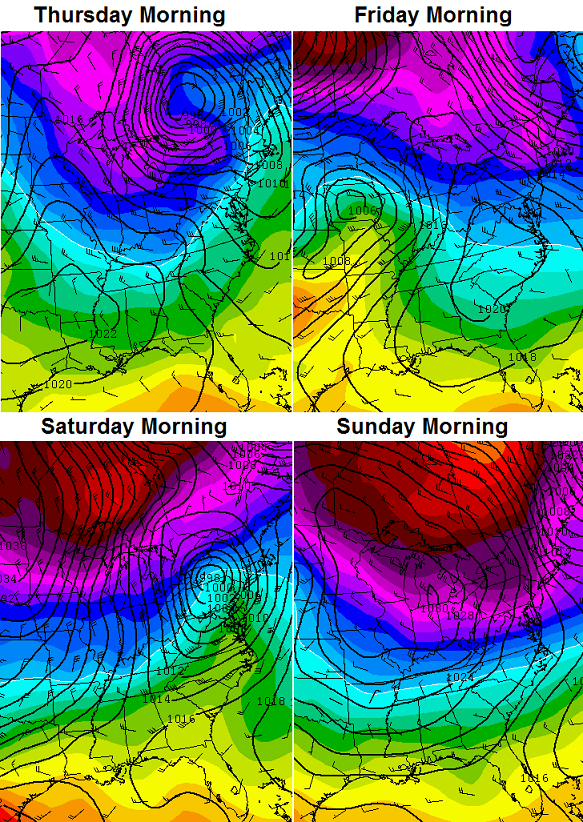 There is a growing signal for some very cold air showing up next week. Check out the huge dip in the jet stream showing up on the European Model…

The European Ensembles strongly agree with cold engulfing much of the country during this time…

A pattern like that is likely to bring more wintry weather our way. Moral of the story… I doubt we’ve seen our last accumulating snow.
Enjoy the day and take care.

I love snow as much as anyone…..but if we can’t get a big one – ten inches would be nice – then I am ready for spring!
Say goodbye to the first generation of insects.
Probably close to 2 inches more snow tonight in east side of frankfort, Chris this winter is crazy!
Maybe an inch (?) in south Lexington.
Keep in mind that even 20° below normal next week is around 40°. (Lexington) So that “very” cold air is not as cold as ones we’ve endured. Remember, it’s spring. Two steps forward, one step back. Progress…
Ive been loving this spring weather myself flowers have bloomed, trees budding and frogs singing
Wow. There’s nothing blooming here. I would be surprised if my Bradford Pears even bloomed out before the 1st of April and they are notorious for blooming first. Tulips still pretty far in the ground as well.
I am in Lexington and saw lots of daffodils blooming yesterday while out running. Cherry trees and even some red maples are starting to bud. It was warm early yesterday but obviously dropped off. Saturday was awesome and almost 70. We’ve only had one day out of the last 10 where it didn’t get to at least 50.
Snow in March is not that unusual and certainly not historic. It usually comes quickly and doesn’t last long and with temps approaching 50 again today I doubt it’ll be here for even 24 hours. The half inch we got at my house was about 6 1/2 inches short of the record.
Got a dusting on elevated surfaces in Pikeville. Lots of warm air last night. Glad you guys to the north got a couple inches!
We got 5 inches here in Flatwoods (Greenup co), No school here again today, We are a city school and we have missed 16 snow days now. We norm only miss 2 or 3 days a winter, we are now at 43 inches of snow this winter.
This pattern has been locked a loaded since last summer. No signs of it letting up. Looks like a cool pool forecast for this summer as we’ll.
Happy St. Patty’s Day to all.
where do you get your info ? just curious, where it’s been said the summer will be cool ? I’ve heard the contrary that it’s going to be normal or slightly above.
Same place that Bryant the blowtorch gets his. I know this guy, that has a brother who’s girl friends’ dad is a uncle of a Met.
No really I read a scientific article two years ago that spoke of a mini ice age that was coming upon us. Talks how weather runs in long cycles, 20 to 30 years at a time. We are coming out of a warmer one and going into a cooler one. Very interesting article and after last summer and this winter I am starting to believe it.
I will have to back bjenks up on this.
I read that very article. The actuals numbers on the charts posted made perfect sense and I feel this is definitely a cooler cycle we are entering.
Not to say we won’t have some very hot summer days still (we will). I just don’t see them lasting terribly long. A pattern locked in like this could yield us one to two cool days for every four to five warm days.
that is interesting – last year’s summer was unbelievable how cool it was. Usually we are swimming in the lake in June, but last year it never really got warm enough to be comfortable.
Not a speck of winter weather in Carrie of knott co. Temp is still in low 30s
Some of the heaviest snow I’ve seen this season occurred in western Kentucky yesterday afternoon but most of it melted on contact. Only a dusting here.
Want spring? Come on down to Southern Kentucky. Never really had a winter in this part of the state. A little bit of cold, but not much snow at all. March is running about 10 degrees above last year. I’m not complaining at all. I will take 50’s and 60’s any day.
And even a near 70 degree day now if we can just have spring and not go straight to summer.
That’s very true bobt. I was very irritated by the lack of snowfall in our area in contrast to northern KY earlier in the winter, but now I am extremely happy that we are in this pattern. Central and northern KY may not have seen its last accumulating snow/sleet/ice for the season, but southern KY certainly has until next Fall/Winter, and I am very grateful for that at this point in the year.
zero snow in Berea last night, just sleet and about 3/4″ of it. Untreated or ‘treated at it’ roads look like fun this morning. Wrecks all over 75 north and south bound last night and again this morning with more of the same.
I know the tendency was to downplay the event due to the low accumulations of snow, but you have to keep in mind that the drivers in this state are horrible on a good day, and thus even worse at the slightest hint of a hazard on the road.
I fully agree about bad drivers. But then again I grew up in Southern California and that is some seriously bad driving too.
New Circle at Alumni shut down by Lexington Police due to the area being a “solid sheet of ice”. 6 vehicle collision at the 111 75 South, only 1 lane open. How long ago did the precipitation move out per CB? These areas are as “primary” as you can get for road treatment.
Kids didn’t even get a snow day here in knott co, spring has set in for good in seky
This met has probably NEVER got a snow forecast wrong before. This was yesterday for the Washington, D.C. area and he forecasted snow of:
Normal: 3-6″
Boom: 6-9″
Bust: less than 3″
Basically, he’s saying 0-9″ He can get away with any forecast, I’ve never seen a thing before. http://www.washingtonpost.com/blogs/capital-weather-gang/files/2014/03/snow_chances_3-15-3-4.jpg
No snow in lily or ice.
And 60s for most of the week
Just the norm around here we’ve not had
The snow Lexington an some others have had
So our story is the same ole same ole.
My pear trees are budding spring flowers
Are in the yard. My granny always told spring
Won’t come till after Easter and Easter is lat April
So there you go. Chris is the best. But it’s hard
To beat granny weather forecast. But granny not
Around no more so Chris your the gut.
I remember coming back to snow in Kentucky not too many years ago in April. We had went to Orlando for spring break and had to wear jackets the morning we left after having very nice weather the whole week. If I’m not mistaking it may have actually been Easter day. I think it snowed all the way down to Atlanta that year. I, and many others lost our Japanese maples that year since they were already in full bloom. I would much rather have a little cold now instead of going into a deep freeze in April.
April 2007.
http://www.crh.noaa.gov/lmk/?n=top_20_weather_events
(skip down to the snow at Keeneland Race Track)
Even snowed during a marathon in Dallas (TX). Freezing temps even in the Florida panhandle. As you touched on, agriculture was hit hard, including peach farmers in Georgia.
3 more days of official winter, after that if we get snow it is spring snow! Chris thinks this will happen, Ugg!
Frankfort close to 30 inches for the season, enough already, save some for December!
Good afternoon fellow weather lovers. We got a very slight bit of freezing rain last night, leaving this above ground icy and a few slick spots on bridges, but that is about all. We did, however get a lot of rain yesterday, along with the gusty winds.
I heard somewhere that we are supposed to get some sunshine at some point this afternoon. Hope that holds true.
I see so may saying that it is spring, but I have to say that the calendar says it will not be here “officially” until closer to the end of this week. So, maybe it really I trying to be winter’s last big hurrah! But, it still looks like it is not going to go with out a fight!
Not really weather related but neither is sports, so….a beautiful, wonderful day for science. 5 sigma!
http://www.bbc.com/news/science-environment-26605974
Snow/ice totals from:
NWS Wilmington OH; their jurisdiction includes part of northern KY (click here).
NWS Jackson KY (click here).
NWS Louisville (click here).
The Facebook page of NWS Charleston WV; their jurisdiction includes part of east KY (click here).