Good Tuesday, friends and neighbors. Milder weather pushes back into the commonwealth today and this sets the stage for some nice stuff. As a matter of fact, most of the rest of the week looks pretty good. Enjoy it because a very cold pattern is loading up to unload on us next week and beyond.
Our day is starting out with some fog and low clouds. The sun will break through by the afternoon and boost temps into the upper 50s to low 60s.
A cold front arrives Wednesday with a couple of showers and gusty winds. Temps will take a tumble behind this and will feel almost chilly at times.
Thursday and Friday look pretty good as milder air floods back int. Friday could find temps hitting the upper 60s in many areas.
This is when things take a turn for the bad. We get a stout cold front to deliver the first shot of cold later this weekend into early next week. That gets followed up by reinforcing shots of cold air through next week. Check out the temperature departures from the European Model…
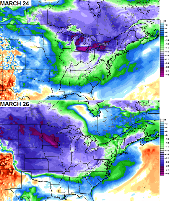 That’s some serious cold invading the country for so late in the season. Why is this happening? It’s a similar pattern to what we had throughout much of the winter with blocking showing up across Alaska. That forces a deep trough into much of the country…

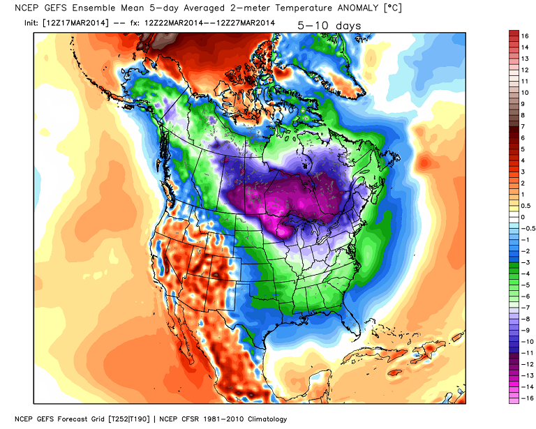
The GFS Ensembles are on board with the cold and keep it going into the start of April…

This is shaping up to be a rather ugly spring for much of the country. Flakes in April are a strong possibility if this pattern continues. Wonder what all those “winters over” forecasters are thinking to themselves right now? 😉 They were telling you it was over before it got started… and not it won’t stop.
Enjoy the day and take care.

Please make it stop!
Sure wish it could be that simple.I am totally worn out as far as winter and want a break from the utility bills.But I guess I can tell myself as long as its cool I won’t need air conditioning.
I suppose a lot of plant life will suffer next month.
I want to give a special shout out to those first daffodils who don’t care to sacrifice themselves by blooming even though they know it will be be a short life. They do this for our enjoyment and sense of hope. Thanks, my yellow friends.
lol
And my pink ones!
Do you have your 4 day weekend off this weekend? I hope so. You have been waiting so long. As far as the weather, I am a snow lover but after this last snow of 7 to 8 inches here in my neck of the woods, Ashland/Catlettburg line, I would be fine now if Spring were to come. I don’t do extreme temps well, whether it is cold or hot but extreme hot temps seem to be worse for me. But if what I am reading here and other places, we should have a cool summer. I kinda like how that sounds. Thanks Chris for all you do!!! I hope you get your time off!!! 🙂
It’s been spring in seky pretty much since March started. Counting today of 18 days we’ve had 4 with highs below 45. 14 days with above 45 and 10 of those was over 55.
amen …. so i’m not a met, but i’m saying IT’S OVER ….. if the “cold spell” means that temps will be in the 40s …. then so be it —- that’s normal. I look at it that we’ve already won on this round with our temps way above normal, plus we are hitting 5 degrees above what is forecasted; this Friday we’ll hit lows 70s easy, but nothing is ever mentioned – only concentration is cold and snow.
Jim, re-read CB’s blog he said it looks to be a pretty nice week weather wise.
Your act is getting very, very old!
Average Temps through March 17th (KLEX Data)
30-Year Normal: 43.4
2014: 39.6
2013: 39.7
Snowfall Through March 17th (KLEX Data)
30-Year Normal (For March 1-17) 0.9
2014: 5.5
2013: 2.5
At least in Central Kentucky, it has been as cold and snowier than last year to this point.
I guess this is more of that “global warming” that I keep hearing about
It is actually.
Yes please tell me more about how man is powerful enough to affect the global weather when man occupies less than 30 percent of the total surface of the earth considering most of the earth is water and plenty of inhabitable land. Global Warming alarmists really have a God complex
you skipped the education years, didn’t you?
Does anyone know anything about Kentucky Utilities being investigated ?
I heard a snippet about it but never heard the story………
Coal ash dumping story.
Temp of 59 not going to happen in frankfort today, stuck in thick clouds and upper 40s UGGGGGG!
Today is the anniversary of the 1925 “Tri-State Tornado” through Missouri, Illinois and Indiana (click link here), just north of Paducah KY. This was one of many deadly twisters from that day, including in Kentucky and Tennessee.
We may never know whether the “Tri-State” was one very long track twister of over 200 miles, or of multiple twisters that still produced a non-stop damage path of over 200 miles. Regardless, the “Tri-State” in many ways is unmatched.
Finally, some peaks of sunshine through the dull overcast here in Nashville 😛 !
thanks Chris!
I’ll enjoy the Spring days we get and really enjoy another Snow or two..get it while you can, I say.
what kinda kool-aid is JJ drinking up there?
GO BIG BLUE and here’s hoping the Reds are better than they look on paper!
Nice day here well into 60s. I wasn’t trying to ruffle feathers just stating that seky has been warmer than most of ky
I think its common to point out the worse weather because it has a more of a ‘need to know’ basics compared to ‘nice’ weather.Doesn’t really matter to much it no one points out it will be really nice someplace but it can be very important to know if very cold,or sleet/snow,etc is on the way.I am just glad to see improvement for the whole state finally.
Not a bad day overall here.Did stay overcast most the day but about an hour ago the sun came out and its still shinning brightly.Got in the 50s this afternoon.Shouldn’t get to cold tonight.So can’t really complain.
He was referring to me Brad which is fine, I’ve been thru more in my life than most people would ever think about, retired Air Force served my country in desert storm, so I can take tough talk. What’s funny is Some People can dog me and nothing gets said to them. Yes Jim Jones is my real name and you think I’ve never heard the kool aid joke before
I’ll visit another site for weather mr bailey but thanks for your awesome attitude toward me for giving opinions. Good day to you.
There are a lot of places in Ky that has had very different weather than what you described for your area.
I think what Jim is looking for is rightwhereimstandingweathercenter.com. KY is a pretty big area, not just where you live.
Jim… you don’t give an opinion… you give a total contradiction to anything I post. You have from day one and that makes you someone with an agenda. I could care less if people agree or disagree with me… that’s more than fine. But when we are one day removed from winter storm warnings and winter weather advisories and you call me out for saying winter won’t end… then I have a serious problem with that. Thanks and take care.
The site is Chris Bailey’s site that I personally read and put more trust in than any other weather blog in the state. I read them all but this one is the most accurate overall. The problem with most people like Jim Jones is they think meteorology is prophecy, its called “forecasting” for a reason….If your gonna call him out then you better get your panties out of a wad because he has every right to call you back out because its his site. He’s doing the best he can to cover the whole state and gives very accurate information, if he’s wrong he admits it….so whats your problem? The winter has been colder than normal regardless of what you think and he’s right…most areas have received above normal snowfall and he’s right….If you don’t have enough faith in his forecast, then why bother except you want to make someone thats doing his job look like the failure when thats not the right way to approach even when you don’t agree….Thanks Chris, your A+ weatherman in my book