Good Wednesday to one and all. Spring continues to missing in action across much of the country. We’re well into the second half of March and there are still no signs of “true” springtime showing up. As a matter of fact… winter still has some work to do for much of the region.
Today’s weather finds a cold front swinging through the bluegrass state. This is touching off a scattered shower or two as it pushes in…

Winds will be rather gusty as this boundary sweeps eastward. Temps behind this will chill down into the 40s from west to east.
Thursday looks pretty good with readings in the 50s under mostly Sunny skies. Friday looks to be the best weather day of the past week and of the upcoming week. Skies will be mostly sunny with temps in the mid and upper 60s.
A cold front arrives on Saturday and this will bring a renewed round of scattered showers and gusty winds. Temps will be in the 50s ahead of this front and then crash behind it into Sunday. That’s when temps will range from the upper 30s to low 40s for highs.
Check out how far below normal temps look to be…
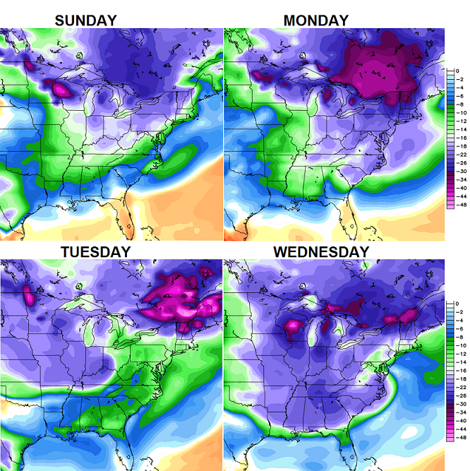 Yep… that is a ton of cold for much of the country and it even extends down into Florida. What about the chance for wintry weather to go along with the cold? There’s a system on Tuesday that tries to answer that question for us…
That’s one for us to keep a close eye on in the coming days.
For those folks who want to argue winter’s over and this is just a typical March… what weather planet are you living on? Temps are way below normal and snowfall is above normal and the pattern ahead shows no signs of true spring. Check out the next 10 days of winter weather from the Canadian Model and tell me if this looks like spring…

If it sounds like I’m trying to smoke a few people out of their holes… you’re right. Sometimes I like a good weather fight. 🙂
Enjoy the day and take care.

Depends on a persons location Mr. Bailey spring has been here in SE Ky for a few weeks and we are not above average for snowfall.it is true that most places maybe colder than normal but an average temp of 42.7 doesnt scream winter imo
An average temp of 42.7 sure doesn’t scream Spring either, IMO…
It looks like it has been a “coolish” March, compared to average, state-wide.
March temp departure from normal (through the 18th)
London -2.7
Jackson -3.3
Covington -3.4
Louisville -3.5
Lexington -3.6
Frankfort -3.9
Paducah -4.7
Bowling Green -4.8
And looking at the 7 day we could be average.
Only Friday looks to be above average and early next week is forecast to be about 15 degrees below average per the NWS…average high is now in the Upper 50’s..forecast highs in the low 40’s. Not sure how that will bring us up to average?
Going to steal a phrase from the WWE former wrestler the Rock. And that’s the bottom line cause Chris Bailey said so!!! lol
Stone Cold!
Oh yes you are right i cant believe i said the Rock. My bad too early in the morning lol
The Rock would say, “Can you SSMMMEEELLLLL what Bailey is cookin’?” LOL
Still much better than March 2013.
As chilly as March 2013 was, that’s still preferable to the March 2 2012 tornadoes in West Liberty, Salyersville, Crittenden KY, East Bernstadt KY, Henryville IN, etc.
Winter isn’t over, but let’s just try to be positive Chris. This has been a long harsh winter for most folks. Either way you look at it the weather is much better now than it was a month or more ago.
So what does qualify as spring? Anybody reply and say what you think it is when true spring arrives. Is it when there is no more snow in the forecast? Lows consistently above 32° or 45°? Highs dominantly in the 70’s? What is YOUR PERSONAL definition?
Nature tells you when spring has arrived when trees and flowers bloom for weeks and the frogs sing for weeks then that’s a sign of spring.
and none of that has been happening….lol buds just started coming out last week a little and the march lillies finally started poking their heads through the ground during the 2 warm days we had last week…..this is a couple weeks at best late and I’m in southern kentucky, not sure what part of Georgia your in
Actually Andy is telling the truth….that has indeed been happening. Here in Middlesboro. the frogs have indeed been screaming for nearly 3 weeks. Buds started popping nearly 2 weeks ago, there are a few trees already becoming a light faint green. Lilies have been blooming for 2 weeks and have seen a couple of red buds blooming. Maybe not in the rest of the state, but Spring is on track and on schedule here on the TN border. Sure we have had a few cold days and a flurry or two, and we may have some more but Spring is definitely overriding winter in this neck of the woods. This in no may an argument against CB, but more often than not (95% of the time) our climate here is more in line with TN rather than the majority of KY. It’s just the way it is.
It has been happening for weeks so i’m not sure what part of Michigan you live in 😛
TN should annex southeast KY. ;>p If Russia can do it, why can’t we?
you must be living in a greenhouse…march lillies just poked through last week and a few blooms now showing up…regardless everything late(usually bloom before feb is over) because the winter keeps dragging on
I get where you are coming from Andy.
I think what CB has been trying to say, is Kentucky as a “whole” is not in Spring mode.
I can confirm, along with many others in Louisville, there have been no frogs singing, no buds, no nothing really.
It is very odd to know that Spring starts tomorrow and there isn’t really a hint of it anywhere in this area. I have lived here since 1998, and can never recall going this deep into March with no signs of Spring (last year included).
refer to my 1st post depends on location us folks that are told we are wrong or get bashed because its different than was predicted have had spring weather.
I get what you are saying.
After this winter, a model map showing 1-2″ of snow for the last 10 days of March.is really no suprise.
That “storm” next week looks well south of Kentucky.
look for it to trend north in time.
The problem is there are so many ways to define “spring.” I agree with Andy. Listen to nature. It knows when warm weather is coming and here to stay.
There is no “normal” spring, only “average” spring. But that is just an average of extremes. On March 11, we were 3 degrees shy of a record HIGH (which was closer than we have been to a record low in the last 30 days or so). But again, we’re just looking at averages. No two “springs” are the same.
I guess we should also point out we’re arguing over whether or not it’s “spring” while it’s still technically winter. The fact that there’s even a disagreement of minds seems to say we’re out of the woods as far as winter is concerned.
Will we get a dusting of snow here and there? Maybe. That has happened before well into April in my memory. We did get one of the winter’s biggest snows earlier in March but that isn’t unusual. 2 out of the 3 biggest snows of the last 20 years or so have been in March.
It does look like we’ll be on the cooler side early next week so get out and enjoy the rest of this week while it’s nice and “springy.”
Thanks Chris. Was looking for sunshine yesterday, but didn’t get any until about 5 pm. I hope we get missed by most of the rain as we got our share with the last snow over the weekend. I would guess we got two inches or more of rain.
As for true spring, remember when it thundered in February? that means frost in May. Guess we will see…..
Have a great Wednesday, everyone. Thanks again Chris for all you do.
Frogs been hollering here for 2 weeks, ducks and geese have paired off and 3 kittens are a week old on my porch. Tells me spring is here.
We were standing on our porch Sunday evening watching the snow and ice fall while listening to the crickets chirp!
Hopefully the models are just in a rut now and they just keep showing the pattern instead of the progressively warmer weather that’s bound to move in now that official spring is upon us, this will break sooner than later and everyone will say its to hot what happen to spring!
so many of you are going to be disappointed when you don’t have your true spring and summer temps.
Yes, spring will be here, sure enough…so will summer.
But, any of you who love the 90 degrees + days, enjoy them. There won’t be a ton of them. I’m banking on a cooler than normal summer. Not to say we won’t have some real heat (we will). However, get used to these winters dragging out and pushing the nice Spring weather back. Some of you may want to move to Florida for the next 15-20 years. 🙂
Last summer was abnormally cool which was just fine with me. What makes you think the scenario you describe will be the new norm? I’d be very happy if it’s true.
I’m betting on hotter and dryer, two cooler and wetter summers in a row in KY is rare!
I guess be prepared for rare to be the new norm 🙂
There was a good article that John Belski posted on his blog about a month ago. I will try to find the link.
It basically has this as being one of the weather cycles we are entering (which is cooler and wetter, like the 60’s and 70’s).
Time will tell if this holds up. But, if you pay attention to patterns, cycles, indices, arctic ice shelf, the list goes on, it seems this could very well be true.
I’m no expert. It just seems we are leaning this direction. I know many would be happy if this ends up being the case, and many would be upset, lol.
I still say we are at the beginning pattern of a mini ice age and the fence area of Kentucky will be the boundary for frozen tundra.
Accuweather indicates after next week’s cold that the trough in east breaks down introducing warmer weather to eastern part of the country.
you lost me at “Accuweather” lol
GO ACCUWEATHER!
haha
Prime example of the weather difference in seky and rest of ky. Cb just tweeted about it being a dreary day while he in Carrie it is brilliant sunshine and near 60. Big difference in the weather from here and central/northern ky
Some buds are trying to come out here in Nashville.
Of course, most of Kentucky has had above normal snow. But has has been mentioned, for some reason areas from Memphis (less than an inch of snow since fall), Nashville (only 1.5 inches) and south eastern Kentucky have had below normal snow. This is despite more southernly cities like Knoxville, Chattanooga, Huntsville, Birmingham, Atlanta getting above normal snow. One to scratch one’s head about.
Still, Nashville has an ice storm in early March that virtually shut down the city. We also had highs virtually in the single digits (lows near zero) in early January.
So I’m ready for spring 😉 .
Knoxville is basically at the same north/south latitude as Nashville. We are much further east, but not really further south. Now the other cities you mentioned (Chattanooga, Huntsville, Birmingham, Atlanta) are further south of both cities.
Well, yes. But part of my point (I perhaps didn’t make clear enough) is that Knoxville has had much more snow this winter than even the London/Somerset KY area to the north. Even Chattanooga has had more snow that parts of Kentucky.
Huntsville AL has had 5.4 inches snow since last fall, which is slightly above normal for them. Yet, Nashville TN is only at 1.5 inches; Nashville’s average is closer to ten.
Yep–big difference. Cold, windy, showery in Lexington. About 50 degrees with a stiff wind.
Getting some clouds down this way now
This weather is just muck, windy, cloudy, drizzle! Come on Mother Nature take a pill and give us a break!
At least yesterday, there were a few peeks of sunshine through the dull overcast (at least here in Nashville).
One of my grade school teachers would ring my neck if I had been discovered using “peak” instead of peek like I did yesterday 😉 !
Snow cover just now melting good in central WV.
I am in Lexington and if by “dreary” he means cloudy then I agree. But at 1:30 p.m. it’s 54 degrees here. We will push 60 today without even a hint of sunshine. The rest of the week and weekend looks nice. We’ll get a few cooler days early next week but just like the last few cold shots, they won’t last. Spring is right on time. We’re just spoiled by all the recent years when we had 70s through most of March. (THAT was abnormal!).
Agree!
63 and sun still in Carrie town.
It would probably be a fairly nice day here if not for the wind.The sun has peeked out a couple of times but only for a few minutes.Temps have set in the 48-52 degree range but it just doesn’t feel that warm.
We hit 62 today under a mostly cloudy sky but with that wind it doesn’t feel like 62 though
The last official day of winter, wow, what a ride for most of KY, I wish some parts of southeast KY had got more snow love but for the northern half of KY it’s been a wild ride, welcome spring Thursday, lets Hope for no extreme severe weather that breaks this winter pattern and thanks Chris and all fellow bloggers for a great winter of fun!
If you want to start provoking something, try making fun of MJ for the “strong signals” of “something” that he’s been hyping for a month that was supposed to happen on March 21st~23rd.
It has to be hyped or nobody will pay attention it is the new norm now.
1987 end of march we had a GIRAFFE HUGGER!!! OLD SCHOOL A COM IN!!! and 1987 coming with it.
case in point hype over a non event
Depends on which part of the giraffe he is refering to – hoof, tail, neck?
I think we will have cold or very cool weather until after the Ky Derby. Happens that way almost every year.
Lord, Please let the weather pattern change soon. Chris Bailey is starting to have anger issues!
Lol