Good Thursday, everyone. Spring blooms in the bluegrass state at 12:57pm eastern time and it’s bringing some better weather with it. The next few days are looking pretty darn good, but Old Man Winter has a lot of fight left as we roll into next week.
In the short term… temps rebound into the 50s today as skies become partly sunny. We will keep a gusty wind that tops out from 20-25mph at times.
Friday looks even better with temps surging into the 60s on a gusty southwesterly wind. Gusts may top 30mph at times under a partly sunny sky. This looks like a gorgeous day and the nicest we see for a while.
That’s because a cold front enters the picture on Saturday and brings scattered showers into town by afternoon. Temps will still be near normal, but will drop from west to east as the day wears on. That front pushes to our south into Sunday as cold air moves in from the north. A few of the models develop a wave of low pressure along this front early Sunday. The Canadian Model…
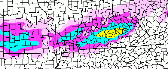
 That could bring a round of rain and snow to the region. The NAM does produce some winter weather by Sunday morning…
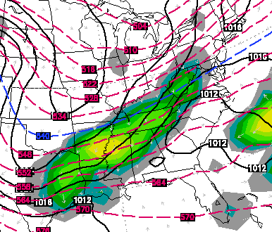
 We will have to see about that as we get closer. This is part of an overall colder pattern settling in for the first full week of spring. A reinforcing shot of cold arrives Monday night into Tuesday and could spawn a storm system developing across the south. The European Model tracks that up the east coast and throws rain and snow into the bluegrass state…
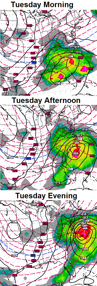
Here’s where that model run shows in terms of winter weather…

Regardless… that’s a heck of a shot of cold coming in behind that and could keep high temps in the 30s for some. For perspective… Normal highs next week hit 60 degrees.
Enjoy your day and take care.

Two years ago we were in the midst of the warmest March on record. I wish we could tap into just a little bit of that warmth. Beginning March 11, here were the daily highs for the rest of March 2012. 67, 64, 74, 77, 78, 66, 74, 77, 79, 83, 82, 80, 72, 63, 69, 62, 67, 79, 67, 78, 61.
On monday, Saint Patricks day, highs were in the 40s, two years ago from that date when I was in Minnesota, I was enjoying 80 degree weather! IN MINNESOTA! It was the earliest recorded 80° temperature there! The normal highs for this time of year are still in the 30s. Record highs were set all over the place for days straight. I just find it ironic that this march and last march (here) have been colder than the one March I was there.
And records do go back to 1872
Wait? U lived in Minnesota, and the largest snow you have seen was the 5 inch snow we had here???
One good thing is that after the unleashed fury of the March 2 2012 tornadoes, severe wx unexpectedly went away from our area for pretty much the rest of that spring.
This year, we of course have had hardly any severe wx. Let’s hope it stays that way, even if April is the most dangerous month for tornadoes in KY/TN.
Storm during 25-26 timeline is very interesting. It will likely become the main focus of the blog over the next few days.
Looking forward to the post about comparing the winter outlook predictions vs. actual. I know the WKYT parking lot would do well in such a comparison, as well areas north and northeast of Fayette. Berea came in about 3 inches below the minimum prediction, which was much better than the year before when we ended up with only 1/2 of the minimum prediction. The last 8 accumulating forecasts from that season yielded nothing for us, that was brutual.
Nobody said Cincinnati was going to get 46 inches of snow. Terrible forecasting! 😉
I think anywhere I-64 and North did well. Lawrenceburg, Frankfort got close to 30 inches and parts of Louisville went past that I do believe.
we are right at 30″ in NE Louisville
My thoughts if the Alaska blocking continues through the summer I am down with it.
Upper 70’s and low 80’s Throughout the summer Would be immaculate.
I hope we are rewarded.
Wouldn’t that be wonderful.No 100 degree days.I am really going to enjoy the next few days of nice weather.May even fire up the grill this weekend.
That would stink for us pool people. No fun swimming in 80 degree temps. Unless you are a kid up to 14 then you would go swimming no matter how cold. I myself like water temps to be in the upper 80’s. To maintain a temp like that throughout the summer we need several 90 degree days. On the other hand I work outside for a living. 70 and 80 degree temps do sound swell. I believe we will see the lower of the two this summer.
I am all for a more mild summer. The last few years here have been very sticky. I wonder when the last frost will be this year?
April 26
So where is this big weather fight I’ve been looking for? 😉
Not even CB could smoke them out of their holes?!
Chris is getting to be a lot like my wife.
I try to argue but she is right 99 percent of
The time. Chris your good at this weather stuuf
But do you ever miss or I wish you would be wrong
Just once about this spring. This old man
Can’t handle much more of this cold dreary
Weather.
Very interesting article about how the average snow has been dropping significantly since the 50s and 60s. It’s for Louisville but Lexington shouldn’t be much of a difference. Basically, this applies to all of KY. Sad, but true.
Forgot the link http://www.wlky.com/weather/how-the-louisville-average-winter-snow-has-changed-over-the-years/25025128
Lol
In 20 – 30 years those averages will slightly higher. Our winter this year will become the norm for the next several years if not longer. I wonder if Mr. Bailey and John Belski will still be blogging in 25 years. LOL
Only if Bubba is here to play the foil to every snow forecast. 😉
In theory
Yes………As long as the earth has been in existence, we only have a little over 100 of records to go buy…….I’m sure this area had many phases with snowless or low snow winters, and many horrendous winters. I’m sure it goes in cycles……….
I REALLY do hope this is a cool summer. We have had really cool summers here before with very few hot days……
2004 stands out for me. I think 2003 had a couple days in the 50s.
2004 was the one I remember the most as well. 0 90 degree days in Lexington. 2009 is a close 2nd–we had a day in June with a high in the 50’s.
I hope the winters like this past one and the ones back then come again. This winter was pretty fun, but it could be better.
My boat on Green River awaits us and we’re ready for a quiet weekend regardless of rain, sleet or snow. It’s warm and toasty on the boat.
Spring is here snow or not!
For what its worth temps here were slightly cooler today than yesterday
I figured if you hit 60 today your trees would be fully leafed out….lol