Good Friday, everyone. We have a wonderful first day of spring taking shape across the bluegrass state with temps well into the 60s. While spring fever is running rampant… readers of the blog know it’s just another false start to the mild weather season. Two shots of winter are possible over the next week.
Let’s start with the nice part of the weather program and that’s today. Highs today will hit the mid to upper 60s on a gusty southwesterly wind. Skies will be partly to mostly sunny. Enjoy!!
Things begin to change on Saturday as a cold front swings in. This may spit out a light shower or two as cooler air slowly seeps in from the northwest. That cool air becomes much colder Saturday night into Sunday. That’s when it meets up moisture from a wave of low pressure developing to our south…
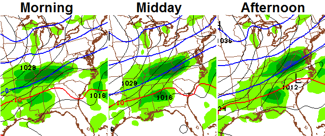
I think the best chance for the wintry weather will be across the southern half of the state. The next winter weather threat comes Tuesday as an even colder shot of air dives in from the northwest as a storm develops to our south. The European Model continues to develop one heck of a storm that rides up the east coast…
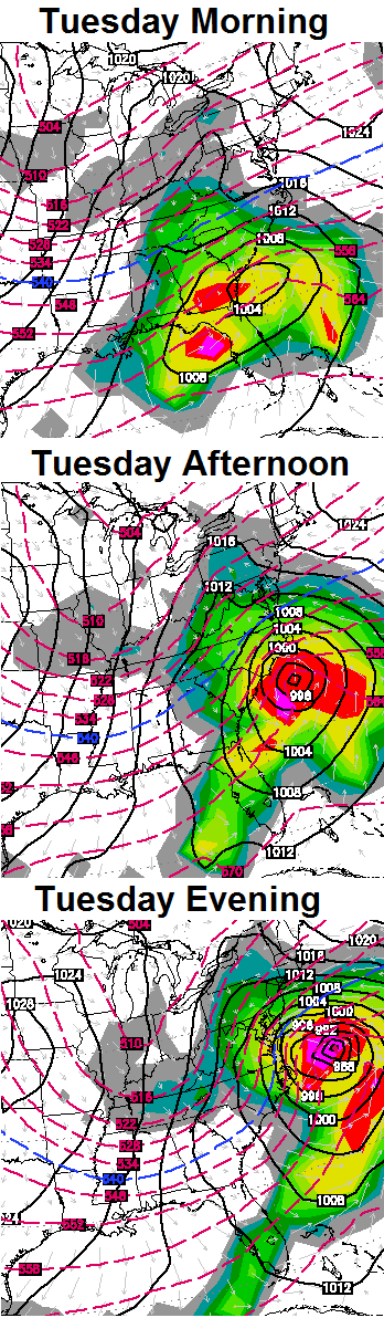
Take a look at the swath of winter weather from that run…
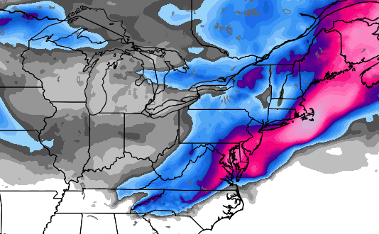
The Canadian Model is similar, but has a little later phase between the storm in the south and the system diving in from the northwest. Regardless, it shows a nice blast of winter for us…
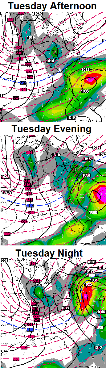
Very cold temps and gusty winds will be likely for Tuesday and Wednesday of next week.
A little good news shows up from the GFS Ensembles by early April…
 Yes, please!
Take care.

Woooohoooo
That’s more like it.
“Readers of the blog know it’s just another false start to the mild weather season.”
“Mild weather season” seems more proper to say than “spring” Spring does not mean warm, it’s just that people as sociate it with temps that are warm enough that are comfortable.
I agree.
I wish the entire forecast was like today’s. I think this Tuesday storm might surprise some people – so at least that will be interesting.
Some wx outlets are suggesting that this upcoming Tuesdayish storm could have a few similarities to the “Superstorm” of March 1993. Even if this comparsion turns out to be a bit of a stretch, the fact that such comparsions are being made sure gets your attention. It will be interesting to see how the models home in on this Tuesday storm between now and early next week.
As discussed many times before, the 1993 blizzard (when I was a kid, about two feet of snow in Morristown TN) is something I and others here on KWC will never forget.
Looks like south-central and western parts of KY as well as most of TN could get a few rumbles of thunder as the first front plunges through on Sat. But any chances of severe wx may be marginal and should stay to the southwest and south of us.
A southern ky tracking storm, go away winter your time is done!
it just means rain as usual Todd nothing wrong with that especially if it doesn’t mean flooding rains
CB …I have a question. With winter weather holding on sooo tight…..does this mean that Aril and May won’t be as bad for tornados? Love spring but NOT tornados like we had a couple of years ago? That year I don’t remember winter lasting as long…but we had a lot of storms.
While CB is obviously better qualified to answer your question than the Monday morning met that is I, a cold spring does not necessarily mean more tornadoes when the wx finally does warm up. Case in point is the spring of 1993. That year was a cold winter and spring (including the infamous March “Blizzard of 93” which also included some fatal Florida tornadoes). Yet that April and May were still below normal for twisters in the USA according to Wikipedia. However, other years with cold springs have had active tornado seasons later in the same spring.
Yes, early 2012 was of course very warm, and we did have lots of twisters from January to the infamous March 2 outbreak. But after March 2 2012, things were thankfully a lot quieter in general despite the continued warmth.
At least to date, the general consensus for this spring is for an average to below average severe wx season in the USA. So far, it’s been one of the slowest starts to severe wx season on record. But even a slow overall year can still have at least one big outbreak.
Thank you…guess I better make sure my severe weather kit is up to date. Gotta get batteries for my weather radio !
On this warm day, March overall continues to run cooler than normal.
Here are the stats through March 20th
Average Temp: 43.8
2014 Average: 40.7
2013 Average: 39.9
2012 Average: 54.3
I saw your post about high temps in the last part of March 2012. That was insane for the good. I think we had a similar run of warmth in 2007 followed by record cold in April where high temps did not get out of the 20’s!
Average highs running about 4 degrees more for this year compared to last in central KY (probably more than that in southern KY. ) This time of year all that matters to me is how warm it gets during the day. Factors such as clear skies at night can skew the temps when posting the average of high and low temps and really has no effect on being able to get out and enjoy the outdoors. For example, yesterdays temperatures had close to normal highs, but because of clear skies last night it dropped all the way down to around 30 degrees. Still got to go outside and enjoy comfortable mid-50 temps. We have had double the number of 50+ high temps this year compared to last.
Weather is now irrelevant. This is all I need baby!
http://www.diddukewin.com/
Topped our at 72 here today
Wow this is cool! For you other weather enthusiasts, I bought “the worlds smallest weather station.” It’s called the Shaka Wind meter. It’s a small device that you can plug into your smartphone’s headphone jack. It measures wind, wind gust, average wind speed, wind chill, heat index, humidity, temperature, and pressure! You can post, and view other people’s data also around the world. It’s so cool, I really recommend it. It’s new and came out within the past couple of months.
They need to make it measure rainfall as well but that might void the phones warranty