Good Wednesday, everyone.Our stormy pattern is finally winding down across the commonwealth of Kentucky. Now comes the cooler weather that will carry us through the rest of the week. The below normal temps will take us through the start of Kentucky Derby Weekend.
We still have the chance for isolated showers and storms across the region today as gusty winds continue. Highs will range from the upper 60s to low 70s, but those numbers will fall from west to east. Track the action…
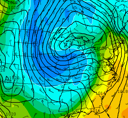
Current temperatures


Thursday will see temps in the upper 50s to low 60s with gusty northwesterly winds setting in. This is a very cool air mass that takes up residence for a few days…
Can lows sneak into the upper 30s in the coldest valleys? That will be something to watch for in the coming days. That’s also a flow that can kick off a stray shower or two during the afternoon hours.
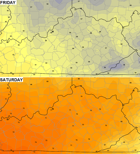
What about Oaks Day and Derby Day? Check out the high temps from the European Model…
 There could be another weak system bringing a shower or two our way by Sunday or Monday. That won’t stick around long as MUCH warmer air floods in next week…
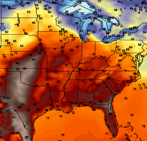
80s are a good bet around here for a couple of days, at least. Check out the blast of 90s in the plains. Wow.
Enjoy the day and take care.

Yay!!!!! Doing a little happy dance that we didn’t get really bad weather.Loving the upcoming cool temps too.Looks like it will be a beautiful start for May.They can keep their 90s over there.Don’t want them.Can deal with a stray shower or two along the way.Just about a perfect forecast for me. [:^)
I’ll take warmer temps any time!
Chris, is there a site where I could find daily rainfall totals by county?
As a gardener, I am very happy to have a few cool days following all these April showers! All this rain will cause the tiny weeds I missed to show themselves so I can get them!
This is my favorite time of year- so much work but so much joy at the end of a terrible winter.
Love being outdoors again!
Wow! Extreme flooding in Mobile, AL / Pensacola, FL!!! Pensacola has had nearly two feet of rain last 24 hours and reports of 24″+ in 24 hours have been reported and this is worse flooding than most hurricanes cause there! Within a 45 minute period, Pensacola reported 5.24 inches. If you do the math there, the rate of rain falling is nearly 7 inches an hour! There is much more info about this and updates on NWS Mobile Twitter page. http://twitter.com/NWSMobile
Looks like we’ll now get into the “ugly” side of this storm system, especially tomorrow! 😉
But yes, look to Mobile/Pensacola if you want to truly “ugly” weather, not to mention all those tornadoes. The tornado that hit Louisville, MS on Monday was scary to watch on video.
Just when I thought we might actually get a cool enough spring to turn out a decent broccoli and spinach crop. The 80s and 90s always show up “ahead of schedule” and burn them up.
Lots of hail with the storms yesterday, in most instances, less than severe criteria.
However, did read of a Twitter report of 3″ hail with picture out of Lawrence County in far east KY!?