Good Sunday, everyone. It’s a much colder setup for the next few days as it FINALLY feels like December. This seasonable brand of cold won’t last very long as the pattern looks to throw one more mild shot our way before a major pattern change to winter takes place. White Christmas lovers should go ahead and pull up last year’s Christmas pics because that’s about the only snow you’re gonna get. 😭
Our day starts with colder winds blowing and the chance for a few flakes flying across the east and southeast…

Temps this afternoon stay in the 30s for most and gusty winds add an extra chill to the air.
The pattern over the coming days looks rather seasonable in the run up to Christmas. As a matter of fact, the 5 day temp average for today through Thursday is a little below normal on the GFS…

The Canadian is solidly colder than normal for the same time…

What happens after this is now a legit question. The Canadian Model trended notably colder for Christmas weekend into early the following week with a couple of systems impacting the region…
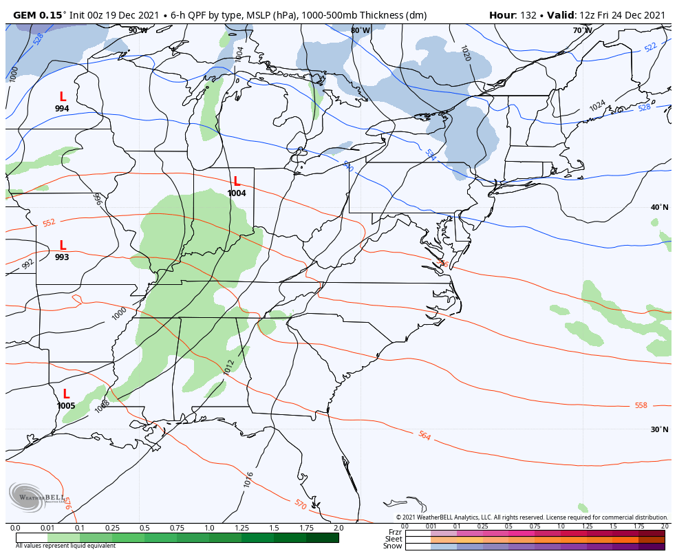
Look at the temp anomalies taking shape across the country during this time…

That last image shows 40 degrees above normal across the lower Mississippi Valley with temps 50 below normal in the upper midwest. 🤯😲
The EURO also has a rather active and colder look…

The GFS is much warmer overall, but the model also trended colder with the ensuing systems right after Christmas…

The overall pattern continues to evolve toward one that can take a VERY cold turn for much of the country as we close the year and begin the new one. The Canadian Ensembles show the massive blocking over the top of the world, leading to a massive trough engulfing much of the country…

The GFS Ensembles are also showing the same thing…

As you know, I’ve thrown around 1984 for a while now as the most similar pattern to what we have now. This excerpt from my November 30th post explains it all…
Before we look ahead, check out this fun fact about November…
Does this mean anything about the winter ahead? The sample size is low, but all three of those winters turned harsh and had memorable events. 1976/77 is legendary and so is 1995/96. 84/85 may be the most underrated winter ever around here. December was incredibly mild before January and February turned crazy cold and snowy.
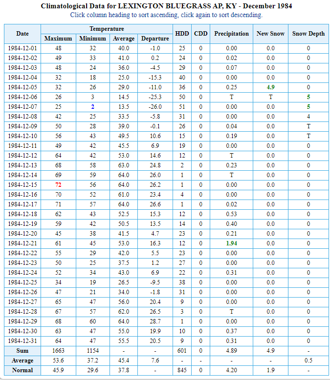
Look at how warm that December was for Lexington…
Think of how crazy snow lovers would be going if that happened today? 👀
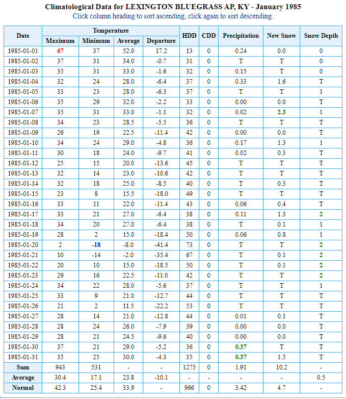
Now, watch how fast this flips after New Year’s Day…
That continued into February…
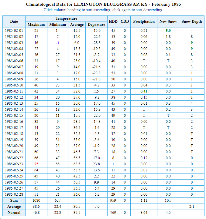
We had snow on the ground for roughly 6 straight weeks.
In retrospect, this was one heck of a foreshadowing post because this December wound up following December 1984 about as closely as you could ask for. Now, this is in no way saying that January and February will go the same way as it did back then, but it’s an interesting analog to follow in the coming days and weeks. Far too many weather folks never look at the past to see what’s even possible around here.
I will have another update later today. Make it a good one and take care.

Thanks Chris, Interesting to look into the weather archives. The Winter of 1969-70 really stands out in my records as the Snowiest Winter in South Central Indiana. One Snowstorm after the other started on the 21st of December 1969 and continued off and on through March 1970.
The years 1976 through 1978 was the latest that really stands out for long periods of bitter Cold and Snow. Snow was on the ground from late January 1977 through March 1978 in Southwest Indiana.
Interesting to point this out that the above Winters I mentioned occurred during weak El Nino years. Two back to back weak El Nino years were recorded from 1976 through 1978.
In my amateur opinion, we Snow lovers need more weak El Nino Winters, but I’ve seen some lame Winters where a weak El Nino occurred : 1987-88 is an example.
The Canadian model showing 40 degrees above normal temperatures for the lower Mississippi Valley verses 50 degree below normal temperatures in the upper Midwest is another SCARY situation. Hope and pray this does not happen !!!
Correction : 1987-88 was a strong El Nino. Apparently, strong El Nino bring blow torch Winters, but not always.
I’m bummed about not having snow for Christmas but, I’m not gonna lie, it’s kinda been nice to have these warmer temperatures this month. I’ll be ready for winter when it decides to arrive. 🙂
I’ve never had high expectations for snow/cold until Jan/Feb……and in some cases even March. As we know, we can have next to nothing around here until Feb…I will never forget Feb 1998…I hadn’t lived here long and that was a massive snowstorm……..One thing is for sure……there’s no analog for a massive long tracked tornado in KY in Dec.