Good Friday, everyone. Wicked wind chills and snow showers are back in the Bluegrass state as Old Man Winter makes a quick appearance. If you’re a cold and snow lover for Christmas, this weather is not going to be sticking around.
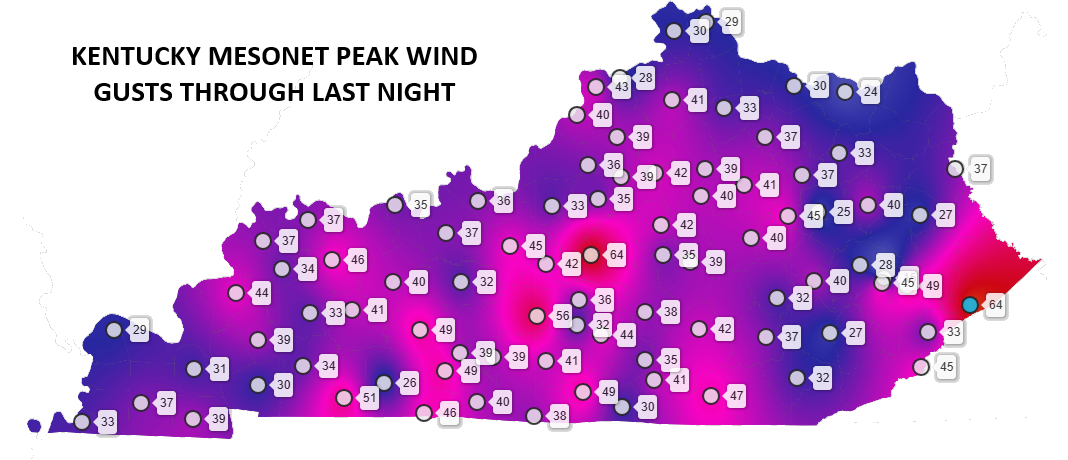
The winds with this system were every bit as wild as advertised with some gusts greater than 60mph…
Black ice is going to be a BIG issue this morning as temps drop into the mid and upper 20s. All that water from the overnight rains will freeze up and we may even have a touch of light snow accumulations on top. Stay alert if you’re driving this morning.
Those snow showers and flurries will be more prominent in the central and eastern parts of the state.
Temps today range from the middle 20s to low 30s for many with winds making it feel much colder. Single digit wind chills will be noted this morning.
This arctic shot doesn’t hit and hold but gets pushed to the northeast of us on Saturday as southwest winds kick in once again. Temps head into the low 50s ahead of another cold front dropping in here early Sunday. That front doesn’t have any moisture with it, but brings seasonably cold air Sunday into early Monday.
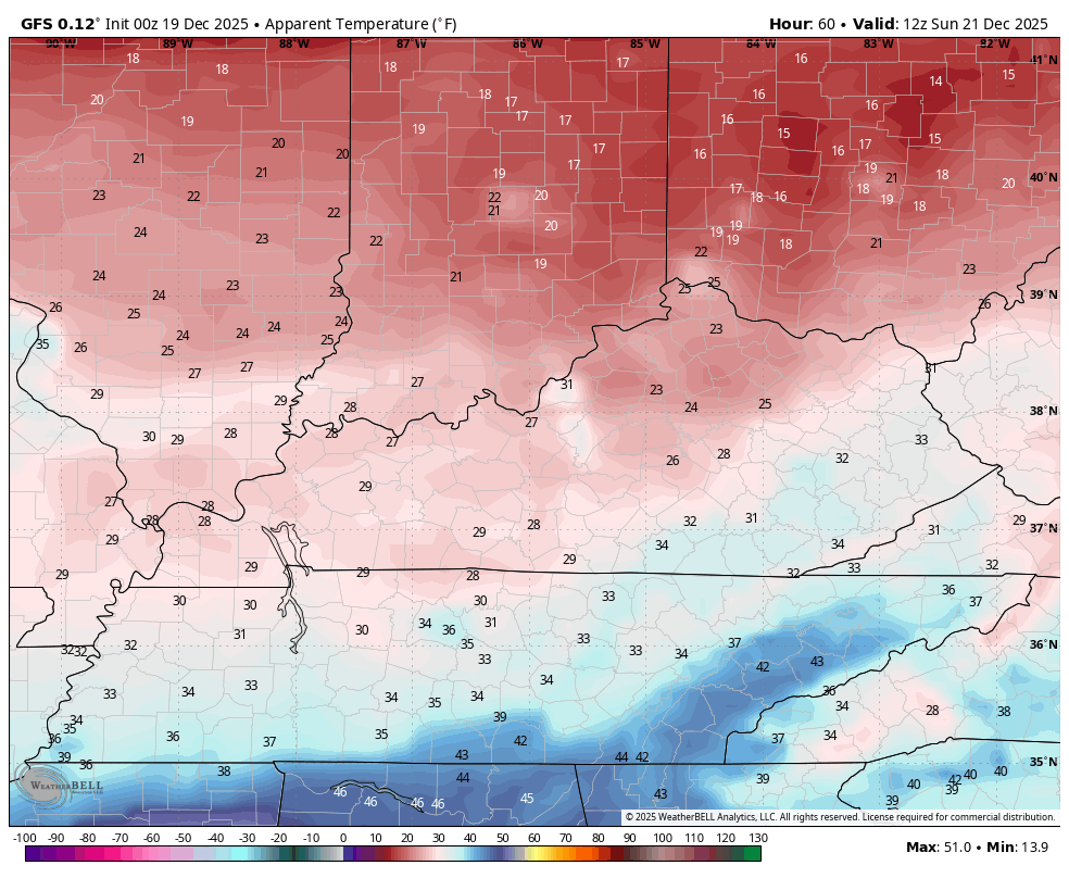
Wind chills from 7am Sunday to 7am Monday look like this…
Warmer air fights in late Monday and Tuesday leading to some showers going up. Some of those may hang around all the way through Christmas…
Those showers are on the leading edge of a major warm up across the Plains with some of that shooting in here for Christmas. Bah Humbug.
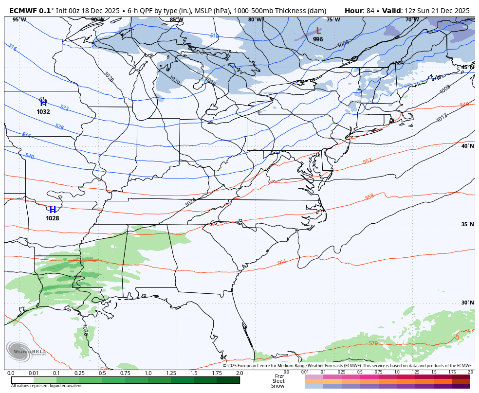
Many of the models are indicating some kind of trough returning to the east shortly thereafter but, as expected, they change from run to run on what to do. The latest EURO looks like this…
Another update will come your way later today, so check back. I will also have a few updates on my Meteorologist Chris Bailey Facebook Page
Until then, here are your tracking tools for the day…


Make it a fantastic Friday and take care.

I knew it was going to rain but I wasn’t expecting rains like that.
Rain > snow or ice
Thanks Chris. We had 1.77 ” of rain yesterday evening. A good soaking rain. Not any Snow flurries to speak of. Stratospheric warming of the Polar Vortex has ended, and now the opposite is occurring. Cold / frigid Arctic air is now lock up. Maybe for the rest of the Winter ? High pressure to our South is being amplified by La Nina, as well as a negative PDO. A very mild Christmas Eve and Christmas Day is in my local forecast, but to me it doesn’t matter what weather type we have on the most religious Day of the year. Snow on the ground does project a peaceful feeling though. Maybe ( JFM, ) we may receive one of those heavy wet Snow events with thunder, which is the best kind of Snow.
Here’s the 2 to 4 week outlook from the Climate Impact Company : )
https://climateimpactcompany.com/u-s-week-2-4-outlook-extreme-cold-central-and-east-u-s-first-half-of-december-reverses-very-warm-second-half-of-december-continuing-in-january-2-2/
Article explaining what is going on in the Northeast Pacific Arena. Marine Heat Wave ( MHW ) is reforming, which may lead to a ENSO / El Nino event next year : )
https://climateimpactcompany.com/u-s-medium-range-forecast-warm-forecasts-continue-warmest-changes-in-the-east-2-2/
We picked up 1.35 inches of rain yesterday, and I recorded a 48mph wind gust.
I am not liking this premature “January Thaw” on bit, 70° on Christmas is ridiculous.
I’ve been tracking the A.I. version of the ECMWF for a while, and it seems to be a bit more accurate, especially over mid-length forecast periods. The GFS has been all over the place for quite a while, so hopefully this new version will help.
I think it will Joe.
Weather on Christmas Day 2024, from the KWC archives : )
https://kyweathercenter.com/?p=68335
About the same. Mild, but maybe a little cooler. It’s this on going La Nina, that doesn’t seem to phase. All because of a negative PDO ( Pacific Decadal Oscillation. ) I kind of wonder if it will ever return to the positive ? It’s been negative for a number of years now. The PDO use to change from month to month, and now it’s going on a decade of negativity. Maybe it’s normal, because the middle name is Decadal.
I agree, the last time it was positive was in 2019! the polar vortex collapse earlier this month has ended. Doubtful if we will see any of that type of occurrence the remaining season. We just cant seem to get all the players to play along +PNA, -AO,-NAO, etc. Well, theres always next year.