Good Friday, everyone. We’ve made it to the end of what has been one of the more active weeks of weather you will ever find around here in August. Unfortunately, some of us will see more in the way of strong storms and more flash flooding.
The rainfall numbers this week are insane for central and eastern Kentucky with locations picking up more than 6″ of rain, leading to all kinds of flash flooding. Given the fact the ground is soaked in many areas, it won’t take much rain to produce more flash flooding issues.
As I’ve said every single day this week, the forecast models have been way off with where they place the corridor of storms and heaviest rains. They’ve been consistently too far north and we must assume that trend continues until they show us something differently.
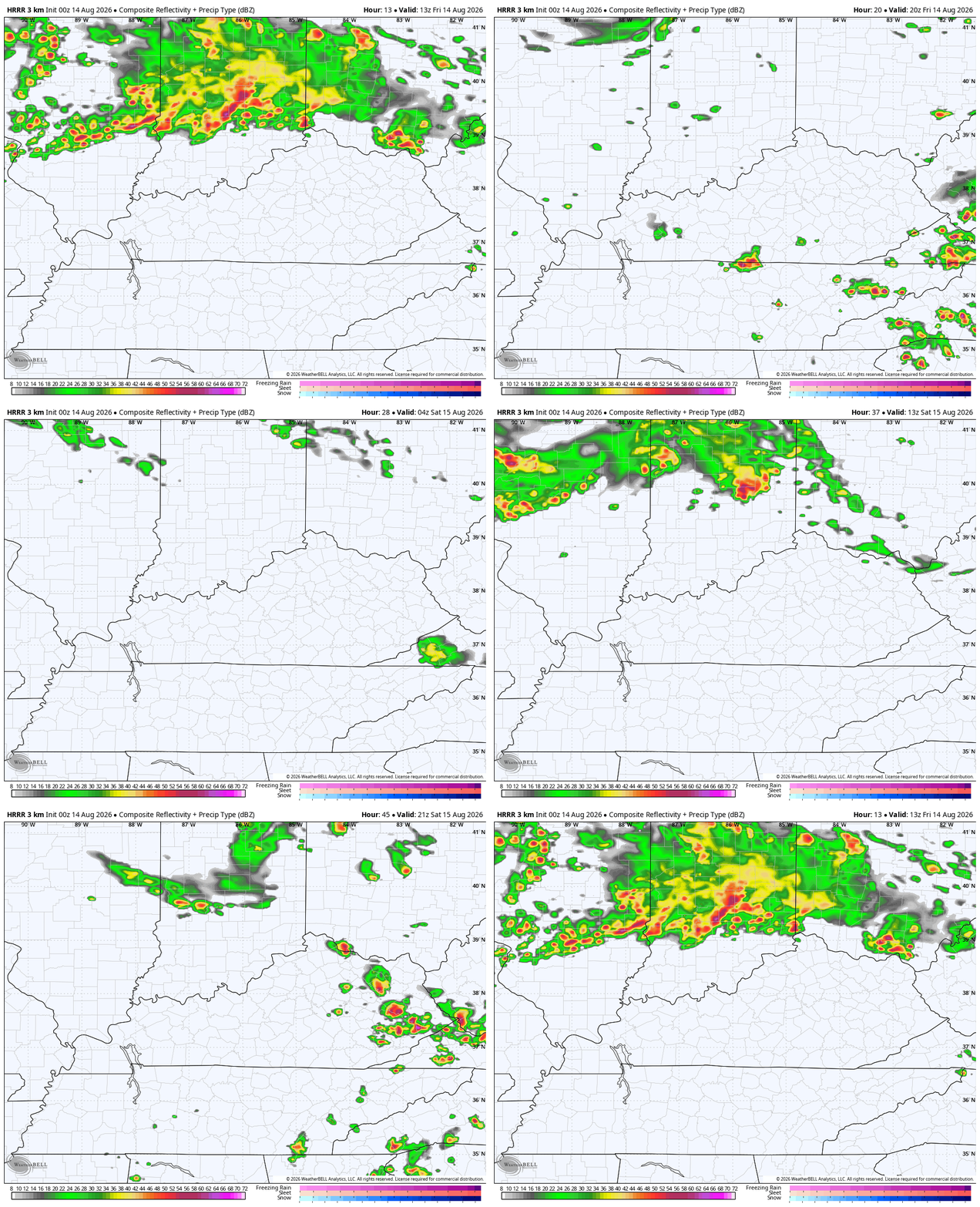
The latest HRRR is trying to adjust a bit farther south compared to earlier runs. Notice how it does see some storms today diving into the state from the northwest and then does so again on Saturday. This future radar goes from this morning through Saturday evening at 8pm…
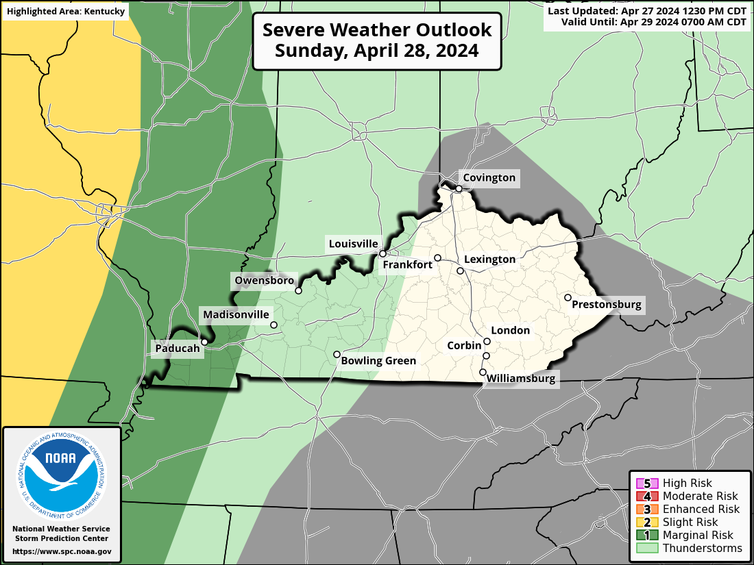
A few of the storms will be strong to severe and we, once again, find the Storm Prediction Center highlighting the severe weather threat for our region today…

Damaging wind is the primary threat and that will be the main threat again with the low-end severe threat for Saturday…
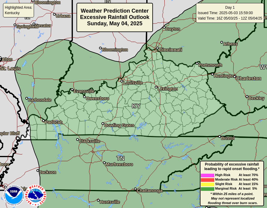
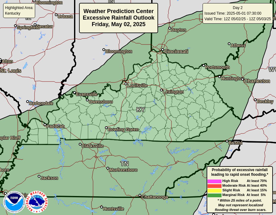
The flash flood risk continues to be there for central and eastern Kentucky over the next few days…
Outside of the storms, it’s an absolute sauna. Humidity levels are sky high, leading to a heat index topping 110 in the west. We may push 100 on occasion farther east into the weekend.
Another threat for isolated storms will be with us on Sunday before the storm chance flares right back up for Monday and Tuesday as a cold front drops in. That will be followed up by what may be a slow-moving cutoff upper level system with more rain later next week and weekend…
Canadian
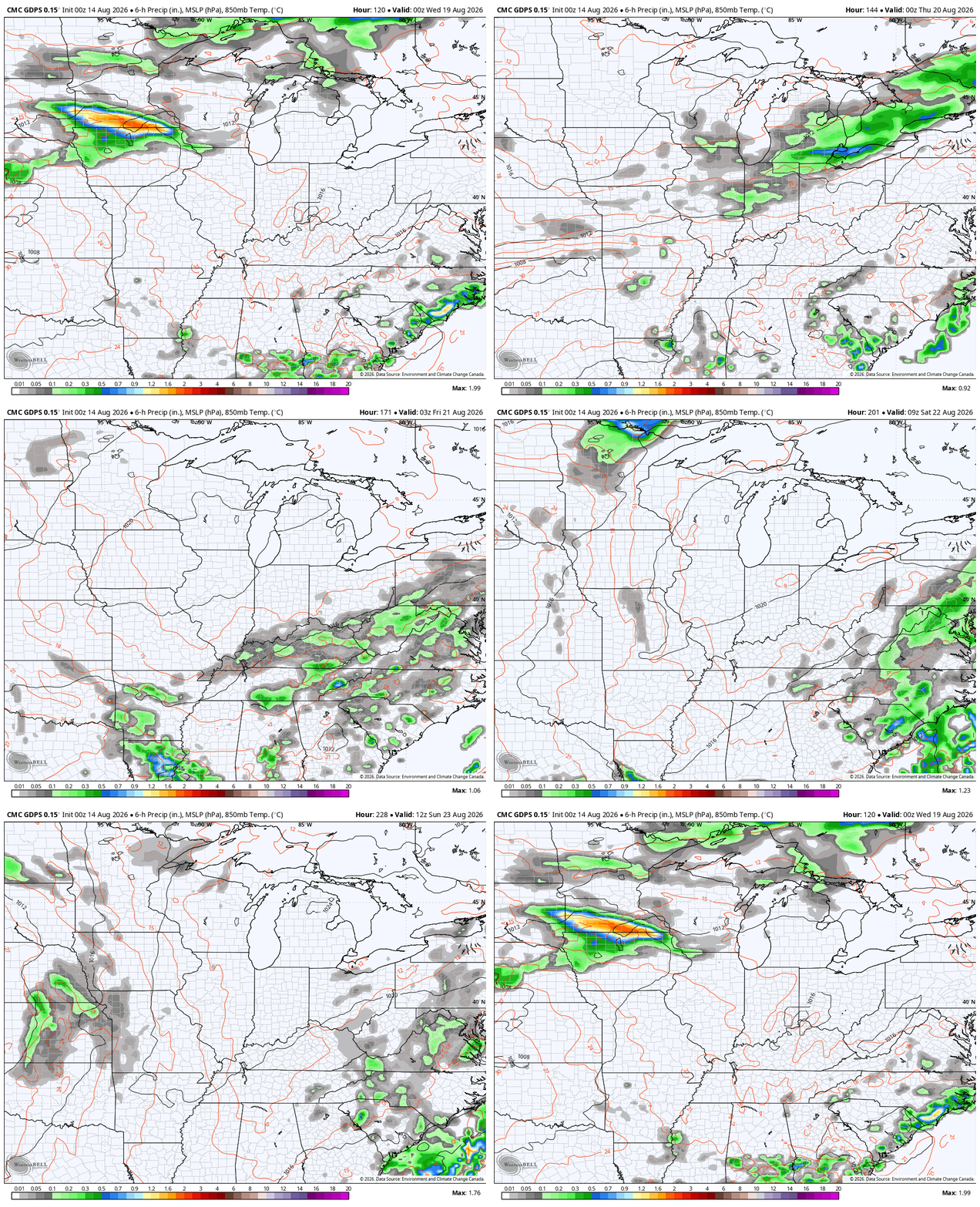
GFS
As always, I leave you with your daily storm tracking toys…







I no longer FEAR the heat now that I have my cold zone in my room with my dual hose portable AC – without having to worry about BLASTING the main central air.
Mark, I remember back in the 1950’s there was no air conditioning. All we had was a window fan.
You never should’ve feared heat.
Thanks Chris. Looking at the radar, the rain and storms are moving more west to east rather than south. My County of Taylor this week recorded 1.56. ” I always welcome any amount of rain in the month of August. Not looking forward to the intense heat and humidity this weekend. Ready for high temperatures in the low 60’s. October type weather.
Can’t wait to see what this ” Super El Nino ” will have on Kentucky’s 2026 – 7 Winter. I read that it could bring a mild, dry Winter, or a colder, snowier Winter. We shall see.
The tropics were starting to get active earlier, but now are encountering upper level wind shear. El Nino doing his job. Here’s the link : )
https://www.weatherstreet.com/hurricane/2026/Hurricane-Atlantic-2026.htm
As was the case earlier this summer, south central Kentucky is baking, with a high yesterday of 97.4°F and a heat index of 111.2°F. My PWS records indicate that we’ve had 23 days where the heat index exceeded 100°F, and that total will easily top 30 days in the week that follows. Rainfall amounts remain way down, with storms staying to the east, north and west. We picked up 0.12 inches so far this week and only 0.92 inches for all of August. Totals for summer are misleading. We have picked up 12.7 inches for the season, but the majority of that fell on 3 separate days, which totaled 2.92, 3.16 and 2.74 inches. The heat dome shows no signs of moving on, with the northern leg of the jet stream staying far to the north
Joe, all I can say about that is to stay indoors. At our age, we have to protect ourselves from heat stroke.
El Nino strengthening continues at a record pace, and the warming in the equatorial Pacific is literally deepening, with far above normal water temperatures being recorded 15 to 20 feet below the surface. Low pressure over the northern Pacific, which usually establishes in the late fall is already in place, thanks to a patch of unusually warm surface waters in that area, which has been in place for much of the year. El Nino effects are not limited to the northern hemisphere, as above normal surface temperatures have been recorded in the Southern Ocean above the coast of Antarctica, where winter is currently in full force.
This El Nino is going to be something that we have never seen. Could be a huge Snow event if Greenland is blocked and the teleconnections are negative. The Arctic Oscillation and the North Atlantic Oscillation.
Bring on the dry, hot weather.
Severe weather hit the Chicago Metro Area hard on Tuesday, particularly the South and SW Suburbs and NW Indiana where a derecho blasted through with straight line winds between 70 and 100 MPH. In addition, six tornadoes have been confirmed in the NWS Chicago territory, ranging from EF-0 to EF-2.
In the SW Suburbs where I live, damage was widespread. The winds were so strong that the power pole in my back yard was literally snapped in two, with the transformer falling in the yard next door, and the wires coming down in several yards. The power was out in my area for 52 hours, just returning on Thursday afternoon. The utility workers did a great job of installing a brand new power pole and connecting all the new wires.
Here’s a link to the summary: https://weather.gov/lot/2026_08_11_Derecho
I saw that Mike. I love general T storms but those are the type of storms I hate… You’re watching out the window cringing thinking any moment major damage is going to happen.
It was really scary! The tornado sirens were blaring, my phone and weather radio went off for the tornado warning, and just a few minutes later those destructive winds started blowing with the sky super dark. It was over rather quickly, but in that short amount of time the damage sure had been done.
I read that this morning about all the damage that occured in Romeoville, and glad you made it through Mike. Now things will get back to normal.
At 10:30 am the current temp at my PWS near Bowling Green is 93°F, dewpoint is 77.2°F and the heat index 106.8°F. Slight breeze out of the SE, feels like a hairdryer.
Jeff, I’m not ashamed to say that this kind of heat is to be feared, or at the very least, given a healthy dose of respect!
I give all weather some respect. I just have my preference. I tolerate winter well, though I just prefer not to drive on snow or ice.
Me either. It would be nice, when we have the temperatures in the upper 90’s and the dew point is in the low 50’s. I could tolerate that.
That’s fair.
Thanks Mr. Schroeder. There are Flood Watches out for most of the Chicago Metro Area later tonight through Saturday morning, with only a marginal threat of severe weather. The main threat will be the torrential rainfall that occurs.
The State of Arizona, has the perfect Climate for you Jeff. You described their Climate perfectly.
I’m returning home tomorrow from visiting family in the southern California high desert. In Apple Valley, CA it’s currently 88° and sunny with 25% humidity and a dew point of 48°. Lows in the morning will be around 60.
At 1:55 pm CDT, my PWS near Bowling Green recorded a high temperature of 100.8°, a dewpoint of 77.9°F, and a heat index of 118°F. There was a light breeze out of the SSW…it was refreshing, if your idea of refreshing is standing in front of a hairdryer!
When I was in Las Vegas last month for vacation, the daily highs were 110 degrees and nighttime lows in the mid to upper 80s. But the relative humidity during the day was only between 4% and 8%, with the lowest dew points in the 30s and low 40s! Even though it’s a dry heat, that sun is really hot. I made the best of it, spending lots of time in the hotel wave pool 🙂